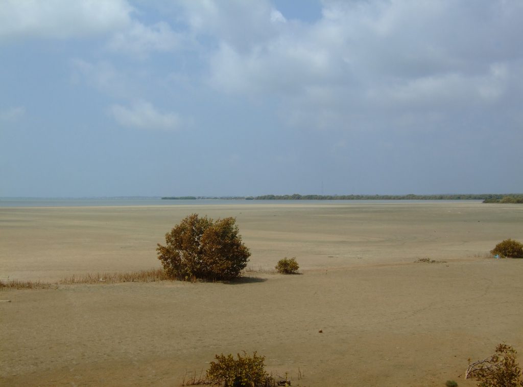
Puttalam Lagoon is the huge body of brackish water beside Puttalam town, on Sri Lanka’s north-western coast. At 327 square kilometres it’s one of the largest lagoons in the country. With its salt pans, mangroves and scattered islands, it’s more a working landscape than a single sight to tick off.
Is it worth visiting?
Go if you want to understand how this stretch of coast actually works. Here it’s salt, fish and rice rather than beaches and surf, on a scale that’s hard to grasp from a map.
Think twice if you came for white sand and watersports. For that, Kalpitiya, on the peninsula between the lagoon and the ocean, is the better fit.
A lagoon the size of a small district
The lagoon stretches up to 28 km in length and 12 km across, covering roughly 327 km². Most of it is shallow, averaging 1–2 m deep, with pockets down to 5 m. Two rivers feed it, the Kala Oya and the Mi Oya. A channel also links it to Mundal Lagoon, 15 km to the south.
Fourteen islands sit inside the lagoon, among them Ippantivu and Erumativu. The water is brackish to saline, and it supports mangroves, seagrass beds and some salt marsh.
Salt, fish and mangroves
The land around the lagoon is put to work in three main ways: salt production, prawn farming and rice cultivation. Fishing goes on across the water too. Meanwhile the mangroves, seagrass and salt marshes attract a wide variety of ducks and other waterfowl.
Puttalam Lagoon and Kalpitiya
It’s easy to mix up Puttalam Lagoon with the water around Kalpitiya, and the two really are connected. Kalpitiya is a long, narrow peninsula with the lagoon on one side and the Indian Ocean on the other. The Dutch built a fort there between 1667 and 1676 to command the entrance to the lagoon.
Still, Kalpitiya’s beaches, dolphins and kitesurfing are a different experience from the main lagoon around Puttalam town. The town side is quieter, more agricultural and much less set up for tourists. If you’re after watersports and resorts, head for Kalpitiya. If you want to see the lagoon as Puttalam’s working waterfront, stay closer to the town.
Seeing the lagoon
There’s no single viewpoint or ticket office; the lagoon is simply the water Puttalam town faces. The waterfront around town gives easy, free views across it. The coast road north towards Kalpitiya and south towards Chilaw also runs close to its shores.
Around Puttalam
Wilpattu National Park lies about 26 km north of Puttalam, if you’re continuing your trip inland. To the south, near Chilaw, is Munneswaram Temple, one of Sri Lanka’s old Shiva temples. For the beach and watersports side of this coast, see the separate guide to Kalpitiya.
Frequently asked questions (FAQs)
Is Puttalam Lagoon the same as Kalpitiya Lagoon?
Not quite. Kalpitiya is a peninsula with Puttalam Lagoon on one side and the ocean on the other. The main body of the lagoon, around Puttalam town, is quieter and more agricultural than Kalpitiya’s beaches and watersports scene.
How big is Puttalam Lagoon?
About 327 km², up to 28 km long and 12 km across. That makes it one of Sri Lanka’s largest lagoons.
Can you swim in Puttalam Lagoon?
It isn’t set up as a swimming spot. Much of it is shallow and used for fishing and salt production rather than recreation. Kalpitiya is the better choice for time in the water.
What is the lagoon used for?
Salt production, prawn farming and rice cultivation are the main uses, alongside fishing. The surrounding mangroves and salt marshes also attract a wide variety of waterbirds.
Header photo: Rehman / Wikimedia Commons, CC BY-SA 4.0.